Measuring land is one of those tasks that seems simple—until you actually try to do it on the ground. If a plot is perfectly rectangular, the process is straightforward. You measure the length, measure the width, and multiply the two values. However, most real-world land is not shaped like a neat rectangle.
In reality, land boundaries are often uneven, sides are of different lengths, and corners rarely form perfect right angles. This is what makes measuring an irregular plot challenging.
Whether you are dealing with a residential plot, agricultural land, or a construction site, understanding how to measure irregular land accurately is essential. Incorrect measurements can lead to costly mistakes in planning, purchasing, or development.
Another common issue is confusion between measuring and calculating. Many people try to jump directly into calculating area without properly measuring the land first. This leads to inaccurate results because the foundation—measurement—is flawed.
What Does “Measuring an Irregular Plot” Actually Mean?
Before diving into methods, it is important to understand what measuring an irregular plot actually involves.
Measuring land does not mean calculating its area directly. Instead, it refers to identifying and recording all the physical dimensions of the plot—such as side lengths, boundary points, and sometimes diagonals or coordinates.
In simple terms, measuring is about collecting data, while calculating is about using that data to determine area.
For an irregular plot, measurement typically includes:
- Identifying all boundary points (corners of the land)
- Measuring the distance between each point
- Recording additional lines such as diagonals if needed
- Creating a rough sketch to represent the shape
Unlike regular shapes, irregular plots do not follow a fixed pattern. This means there is no single measurement formula that works for every case. Instead, the goal is to capture enough accurate information so the shape can later be broken down into simpler forms.
Understanding this distinction removes a lot of confusion and helps you approach the task in a structured way.
Key Principle: Break the Land into Measurable Segments
One of the most effective ways to measure irregular land is to think in terms of segments rather than the entire shape.
Instead of trying to measure the plot as a whole, you divide it into smaller, manageable sections. These sections are easier to measure and can later be used for area calculation.
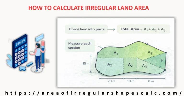
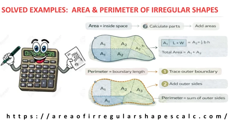
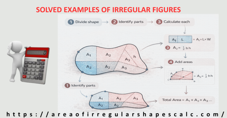
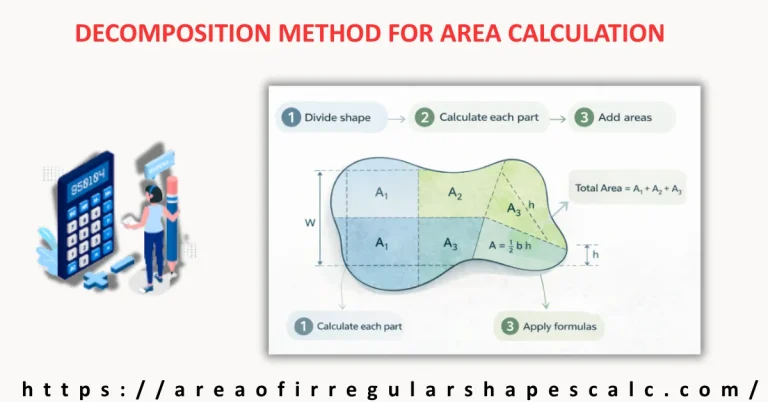
For example, an irregular four-sided plot can often be split into two triangles by drawing a diagonal line. Similarly, more complex plots can be divided into a combination of triangles and rectangles.
This segmentation approach simplifies both measurement and calculation. It allows you to focus on smaller parts, ensuring that each measurement is accurate and easy to verify.
Another advantage of this method is flexibility. No matter how irregular the plot is, it can always be divided into simpler components.
This principle is widely used by surveyors, engineers, and construction professionals because it transforms a complex problem into a series of simple steps.
Method 1: Measuring Irregular Land Using Tape or Chain
The manual method is one of the most traditional and widely used approaches for measuring irregular land. It is especially useful for small to medium-sized plots where advanced tools may not be available.
The process begins by physically walking the boundary of the land and identifying all corner points. These points should be clearly marked using stakes, flags, or any visible indicator.
Once the boundary points are established, you measure the distance between each consecutive point using a measuring tape or chain. This gives you the side lengths of the plot.
However, measuring just the sides is often not enough for irregular shapes. To improve accuracy, you should also measure diagonals between non-adjacent points. Diagonals help define the internal structure of the shape and make it easier to divide the land into triangles.
After recording all measurements, create a rough sketch of the plot. Label each side and diagonal clearly. This sketch will serve as a reference when you move on to area calculation.
While this method is simple and accessible, its accuracy depends heavily on careful measurement. Even small errors in reading or recording distances can affect the final result.
Despite its limitations, the manual method remains a practical solution for many real-world situations.
Method 2: Measuring Irregular Plot Using GPS or Mobile Apps
With advancements in technology, measuring irregular land has become much easier and more efficient. GPS-based tools and mobile apps allow you to measure land without physically measuring every side.
In this method, you use a smartphone or GPS device to mark the boundary points of the land. By walking along the edges of the plot, the device records your position and creates a digital outline of the shape.
Many applications allow you to simply tap on a map to mark points, especially when using satellite imagery. Once all points are marked, the software automatically connects them to form the plot boundary.
The biggest advantage of this method is speed and convenience. It reduces manual effort and minimizes human error in measurement.
GPS-based measurement is particularly useful for large plots, agricultural land, or areas where physical measurement is difficult.
However, accuracy can vary depending on signal strength, device quality, and environmental conditions. For critical measurements, it is always a good idea to verify results using another method.
Overall, GPS tools provide a modern and efficient way to measure irregular plots, especially when used correctly.
Method 3: Using Coordinates (Surveying Method)
The coordinate method is commonly used by professional surveyors and engineers. It involves representing each boundary point of the land using coordinates, typically in the form of (x, y).
These coordinates define the exact position of each point on a map or grid. Once all points are recorded, they can be connected to form the shape of the plot.
The advantage of this method is precision. It allows for highly accurate measurement of irregular land, especially when combined with modern surveying equipment.
This method is widely used in legal land documentation, mapping, and large-scale development projects.
While it may seem complex for beginners, many tools and software systems simplify the process by handling calculations automatically.
For everyday use, this method may not always be necessary. However, understanding it gives you insight into how professionals measure land with a high degree of accuracy.
How to Measure Uneven or Sloped Land Accurately
Not all land is flat. In fact, many irregular plots include slopes, elevations, or uneven terrain. Measuring such land requires a slightly different approach because the surface distance is not the same as the horizontal distance.
When land is sloped, measuring directly along the surface can lead to overestimation. This happens because the tape or measuring tool follows the incline rather than the true horizontal projection of the land.
To measure sloped land accurately, the goal is to determine the horizontal distance between points rather than the surface distance. This can be done in a few practical ways.
One approach is to use leveling techniques. You can hold the measuring tape horizontally between two points instead of laying it along the ground. This helps approximate the true horizontal length.
Another method involves breaking the slope into smaller flat segments. By measuring shorter, more manageable sections, you reduce the impact of elevation differences and improve overall accuracy.
For professional work, tools like leveling instruments or total stations are used to measure elevation and calculate true horizontal distances precisely.
Understanding the difference between surface measurement and horizontal measurement is essential when dealing with uneven land. Ignoring this factor can result in noticeable errors in the final area calculation.
Common Mistakes When Measuring Irregular Land
Even when using the correct methods, small mistakes can lead to inaccurate measurements. Being aware of these common errors can help you avoid them.
One of the most frequent mistakes is failing to mark boundary points clearly. Without proper markers, it becomes difficult to ensure that measurements follow the exact edges of the land.
Another common issue is measuring only the outer sides and ignoring diagonals. For irregular shapes, diagonals are often necessary to define the internal structure and allow proper segmentation.
People also tend to assume straight boundaries where there may be slight curves or irregularities. This assumption can distort the actual shape of the land.
Inconsistent units are another source of error. Mixing meters and feet without conversion leads to incorrect calculations. Always ensure that all measurements use the same unit system.
Finally, rushing the process can result in recording errors. Taking time to double-check measurements and verify values can prevent costly mistakes later.
Avoiding these common issues ensures that your measurements are reliable and ready for accurate area calculation.
Practical Tips for Accurate Irregular Plot Measurement
Accurate measurement is not just about tools—it is about approach and attention to detail. Following a few practical tips can significantly improve your results.
Always begin with a rough sketch of the land. Even a simple hand-drawn diagram helps you organize measurements and visualize the structure of the plot.
Label every point and measurement clearly. This reduces confusion and ensures that no data is missed during calculation.
Take measurements more than once whenever possible. Rechecking distances helps identify inconsistencies and improves accuracy.
Use diagonals strategically. Measuring diagonals allows you to divide the land into triangles, which are easier to handle mathematically.
If the plot is large or complex, consider combining methods. For example, you might use manual measurement for smaller sections and GPS tools for larger boundaries.
Whenever available, use digital tools to verify your results. Modern apps and mapping software can serve as a reliable backup to manual measurements.
These simple practices can make a significant difference in achieving precise and dependable land measurements.
What to Do After Measuring the Plot
Once you have measured all sides, diagonals, or coordinates of the irregular plot, the next step is to convert these measurements into area.
At this stage, you can apply different methods depending on the data you have collected. If you have divided the land into triangles or rectangles, you can calculate the area of each section and add them together.
If you are working with coordinates, you can use coordinate-based formulas or tools to compute the total area directly.
For convenience and speed, many people prefer using online tools or calculators designed specifically for irregular plots. These tools allow you to input measurements and get accurate results instantly.
The key point is that measurement is only the first step. Accurate measurement provides the foundation, but proper calculation completes the process.
11. Frequently Asked Questions (FAQs)
1. How do you measure irregular land manually?
To measure irregular land manually, identify all boundary points, measure the distance between each point using a tape or chain, and record diagonals where needed. Create a sketch to organize the measurements before calculating the area.
2. What is the best tool to measure an irregular plot?
The best tool depends on the size and complexity of the land. Measuring tape works well for small plots, while GPS devices and mobile apps are more suitable for larger or complex areas.
3. Can I measure irregular land using Google Maps?
Yes, Google Maps allows you to mark points and measure distances between them. It is a convenient option for estimating land measurements, especially when physical access is limited.
4. How accurate is GPS land measurement?
GPS measurement can be quite accurate, but it depends on signal quality and device precision. For critical measurements, it is recommended to verify results using another method.
5. Do I need a surveyor to measure irregular land?
For small or non-critical measurements, you can measure land yourself using basic tools. However, for legal documentation, construction, or large projects, hiring a professional surveyor is recommended.
Final Words:
Measuring an irregular plot may seem complex at first, but with the right approach, it becomes a clear and manageable process.
By understanding how to identify boundary points, measure distances accurately, and account for uneven terrain, you can capture all the necessary data for precise land analysis.
Whether you choose manual methods, GPS tools, or professional surveying techniques, the key is consistency and attention to detail.
Remember that accurate measurement is the foundation of accurate area calculation. Once your measurements are reliable, the rest of the process becomes straightforward.
With the knowledge from this guide, you can confidently measure any irregular plot and move forward with planning, construction, or evaluation without uncertainty.