Calculating the area of land sounds simple—until you actually try to do it. In theory, measuring land is straightforward when the shape is a perfect rectangle or square. You multiply length by width, and you’re done. But in reality, most land plots are far from perfect geometric shapes.
If you’ve ever looked at a piece of land and noticed that all sides are different lengths, boundaries are uneven, or angles are not right angles, you’ve already encountered what is known as irregular land. This is where confusion begins for most people.
Many landowners, buyers, and even students often wonder how to calculate the area of irregular land or how to deal with plots that don’t follow standard shapes. The challenge becomes even more frustrating when there are no clear formulas that directly apply to such shapes.
What is Irregular Land?
Irregular land refers to any plot that does not conform to standard geometric shapes such as rectangles, squares, or circles. In such plots, sides may be unequal, angles may vary, and boundaries may not run parallel.
In real-world scenarios, most land parcels are irregular due to natural terrain, historical boundaries, or construction adjustments. Agricultural fields, residential plots, and inherited land divisions often result in shapes that are uneven and unpredictable.
For example, a piece of land may have four sides, but none of them are equal, and the angles between them are not 90 degrees. In other cases, a plot may have more than four sides, forming a complex polygon.
Despite this apparent complexity, all irregular land shapes share one important characteristic: they can always be broken down into simpler geometric components.
The Key Principle Behind Calculating Irregular Land Area
The most important concept you need to understand is this:
You never calculate the area of an irregular shape directly.
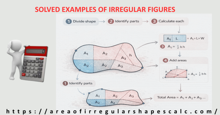
Instead, you simplify the problem by dividing the land into smaller, regular shapes whose areas can be calculated easily.
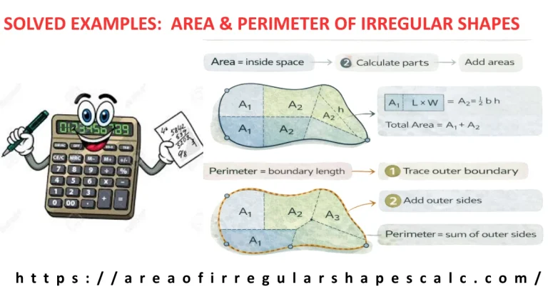
These simpler shapes typically include rectangles, triangles, and sometimes trapezoids. Each of these shapes has a well-known formula, which makes the calculation process straightforward.
Once the irregular plot is divided into these manageable sections, you calculate the area of each section individually and then add them together to get the total land area.
This method is widely used in land surveying, construction planning, and real estate evaluation because it is both practical and reliable.
Think of it like solving a puzzle. Instead of trying to understand the entire complex shape at once, you break it into smaller pieces, solve each piece, and then combine the results.
This principle forms the foundation of almost every method used to calculate irregular land area.
Method 1: Decomposition Method (Most Common Approach)
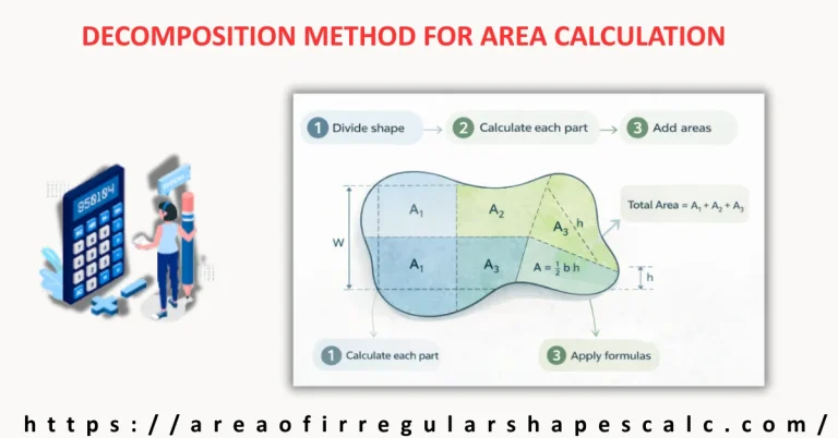
The decomposition method is the most commonly used and practical way to calculate the area of irregular land. It involves dividing the plot into smaller, regular shapes and calculating each part separately.
The process begins by sketching the land as accurately as possible. Even a rough diagram helps you visualize how the land can be divided. Once you have a sketch, identify sections that resemble familiar shapes such as rectangles or triangles.
For instance, a four-sided irregular plot can often be divided into two triangles, or into one rectangle and one triangle. More complex plots may require multiple divisions, but the idea remains the same.
After dividing the land, measure the necessary dimensions for each section. For rectangles, you need length and width. For triangles, you typically need base and height.
Next, apply the appropriate formulas to calculate the area of each section. Finally, add all the individual areas together to obtain the total area of the land.
The strength of this method lies in its flexibility. No matter how complex the land shape appears, it can always be simplified into smaller parts.
This is why the decomposition method is widely recommended for calculating irregular plot areas in real-world situations.
Step-by-Step Example: Calculating Area of an Irregular Plot
To understand how this works in practice, let’s walk through a realistic example.
Imagine a piece of land that has an uneven shape. After sketching it, you divide it into two parts: a rectangle and a triangle.
The rectangular section has a length of 20 meters and a width of 10 meters. Using the standard formula, its area is calculated by multiplying length by width, which gives 200 square meters.
The triangular section has a base of 10 meters and a height of 8 meters. The area of a triangle is calculated using half of the product of base and height, which results in 40 square meters.
Once both sections are calculated, you add them together. The total area of the land becomes 240 square meters.
This example demonstrates how a complex-looking plot can be simplified into basic shapes, making the calculation process much easier and more intuitive.
In real scenarios, the number of sections may vary, but the approach remains the same. The more accurately you divide the land, the more precise your final result will be.
Method 2: Using Coordinates for Irregular Land Area
In modern land measurement, coordinates are often used to calculate the area of irregular plots, especially when dealing with digital maps or survey data.
In this method, each corner of the land is represented by a coordinate point, usually in the form of (x, y). By connecting these points in sequence, the shape of the land is defined mathematically.
Using these coordinates, the area can be calculated through a systematic formula that processes all points together. While the underlying mathematics may seem complex, many tools and software systems perform these calculations automatically.
This method is particularly useful when dealing with large plots, GPS data, or professionally surveyed land.
However, for manual calculations or smaller plots, the decomposition method remains more accessible and easier to apply.
Understanding both methods gives you flexibility. You can choose the approach that best suits your situation, whether you are working with physical measurements or digital data.
How to Measure Irregular Land Area Accurately
Before you can calculate the area of irregular land, you must first measure it correctly. This is where many people make mistakes. Even the best formulas will give incorrect results if the measurements are not accurate.
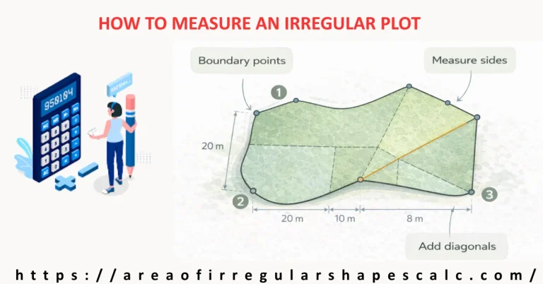
The process of measuring irregular land begins with identifying all boundary points. These are the corners or turning points of the land. Each point should be clearly marked, either physically on the land or noted on a sketch.
Once the boundary points are identified, you measure the distance between each consecutive point. This can be done using measuring tape for small plots, but for larger areas, tools such as measuring wheels, GPS devices, or surveying instruments are more reliable.
In many real-world cases, especially in construction or real estate, professionals use coordinate-based measurement systems. GPS mapping tools or land surveying software can record exact coordinates of each point, making area calculation much more precise.
Another important aspect is ensuring that measurements follow the actual boundary, not an assumed straight line. Land edges are often slightly curved or uneven, and ignoring these variations can lead to errors.
A good practice is to double-check measurements and, if possible, take them from multiple reference points. Accuracy at this stage ensures that your final area calculation is reliable.
Common Mistakes When Calculating Irregular Land Area
Even with the right methods, errors can occur if the process is not handled carefully. Understanding common mistakes helps you avoid them and improves the accuracy of your results.
One of the most frequent mistakes is trying to apply a single formula to an irregular shape. Since irregular land does not follow a standard pattern, forcing it into a formula designed for regular shapes often leads to incorrect results.
Another common issue is incorrect division of the land. If the plot is not divided properly into simple shapes, calculations become inconsistent. For example, choosing awkward divisions instead of logical geometric sections can complicate the process.
Measurement errors are also a major problem. Even small inaccuracies in side lengths or heights can significantly affect the final area. This is especially true for larger plots, where errors accumulate.
People also tend to ignore units. Mixing meters, feet, or yards without proper conversion leads to completely wrong calculations. Always ensure that all measurements are in the same unit before starting.
Finally, overlooking angles or diagonals in certain shapes can lead to incomplete calculations. In some cases, additional measurements such as diagonals are necessary to divide the land correctly.
Avoiding these mistakes ensures that your calculated area is as close to reality as possible.
Practical Tips for Calculating Area of Irregular Land
Calculating irregular land area becomes much easier when you follow a structured approach and apply practical strategies.
Start by always sketching the land. Even a rough drawing helps you visualize the shape and identify how to divide it. Without a sketch, it is easy to lose track of measurements.
Next, divide the land into the simplest shapes possible. The simpler the shapes, the easier the calculations. Avoid overcomplicating the divisions.
Label every side and dimension clearly on your sketch. This prevents confusion later and ensures that no measurement is missed.
When dealing with large or complex plots, consider breaking the land into more sections rather than fewer. Smaller sections are easier to calculate accurately.
If you have access to digital tools or mapping software, use them. Modern tools can significantly improve accuracy and reduce manual effort.
Finally, always verify your results. Recalculate or cross-check using a different method if possible. This extra step can help catch errors before they become costly mistakes.
Real-World Applications of Irregular Land Area Calculation
Understanding how to calculate irregular land area is not just a mathematical exercise—it has real-world importance across multiple fields.
In real estate, accurate land measurement determines property value. Buyers and sellers rely on precise area calculations to make informed decisions.
In construction, knowing the exact land area is essential for planning buildings, allocating space, and estimating material requirements.
Agriculture also depends heavily on land measurement. Farmers use area calculations to plan crop distribution, irrigation systems, and resource management.
Urban planning and land development projects require accurate measurements to ensure proper layout and compliance with regulations.
Even homeowners may need to calculate irregular land area when designing gardens, fences, or extensions.
In all these cases, the ability to calculate irregular land accurately ensures efficiency, cost control, and better decision-making.
FAQs
1. How do you calculate the area of irregular land with different sides?
To calculate the area of irregular land with different sides, divide the plot into smaller regular shapes such as triangles or rectangles. Calculate the area of each section individually and then add them together to get the total area.
2. What is the easiest way to calculate irregular plot area?
The easiest method is the decomposition method. By breaking the land into simple shapes and calculating each separately, you can simplify even complex plots into manageable calculations.
3. Can I calculate irregular land area without angles?
Yes, in many cases you can calculate the area without knowing angles by dividing the land into triangles and using base and height measurements. However, for more complex shapes, additional measurements may be required.
4. How do surveyors calculate irregular land area?
Surveyors often use coordinate-based methods. They record the coordinates of each boundary point and use specialized formulas or software to calculate the total area accurately.
5. How accurate are online irregular land area calculators?
Online calculators can be highly accurate if you input correct measurements. However, their accuracy depends entirely on the quality of the data you provide.
Final Words
Calculating the area of irregular land may seem challenging at first, but with the right approach, it becomes a structured and logical process.
By understanding the key principle of breaking complex shapes into simpler parts, you can handle any irregular plot with confidence. Whether you use manual methods like decomposition or advanced techniques like coordinate calculations, the goal remains the same: accuracy and clarity.
The most important takeaway is that irregular land does not require complicated formulas—it requires the right strategy.
With proper measurement, careful division, and step-by-step calculation, you can determine the area of any land shape accurately.
Whether you are a student, landowner, or professional, mastering this skill gives you a practical advantage in real-world situations.